
US67CleburneBypass,Cleburne,JohnsonCounty,Texas
___________________________________________________ARRATIGERAPPLICATION
Page 1 of 25
TIGER DISCRETIONARY PROGRAM
Project Application
Name of Project: US 67 Cleburne Bypass
Agency Submitting Project: North Central Texas Council of Governments
Primary Contact:
Name: Michael Morris
Phone Number: 817.695.9241
Email Address: [email protected]
Type of Project: Highway
Project Location:
City: Cleburne
County: Johnson
State: Texas
Congressional Districts: Chet Edwards (District 17)
Rural or Urban Area? Rural
TIGER Funds Requested: $ 50,000,000
DUNS Number: 10-246-2256

US67CleburneBypass,Cleburne,JohnsonCounty,Texas
___________________________________________________ARRATIGERAPPLICATION
Page 2 of 25
General Project Information
- for a Summation of this project’s general benefits see page 24.
A Cost/Benefit Analysis is provided on page 25.
.
Submitting Agency/Grant Recipient: North Central Texas Council of Governments
(NCTCOG)
Implementing Agency: Texas Department of Transportation (TxDOT)
Project Name: US 67 Cleburne Bypass
Project Limits: From US 67 West of Cleburne to Spur 102, east of Cleburne
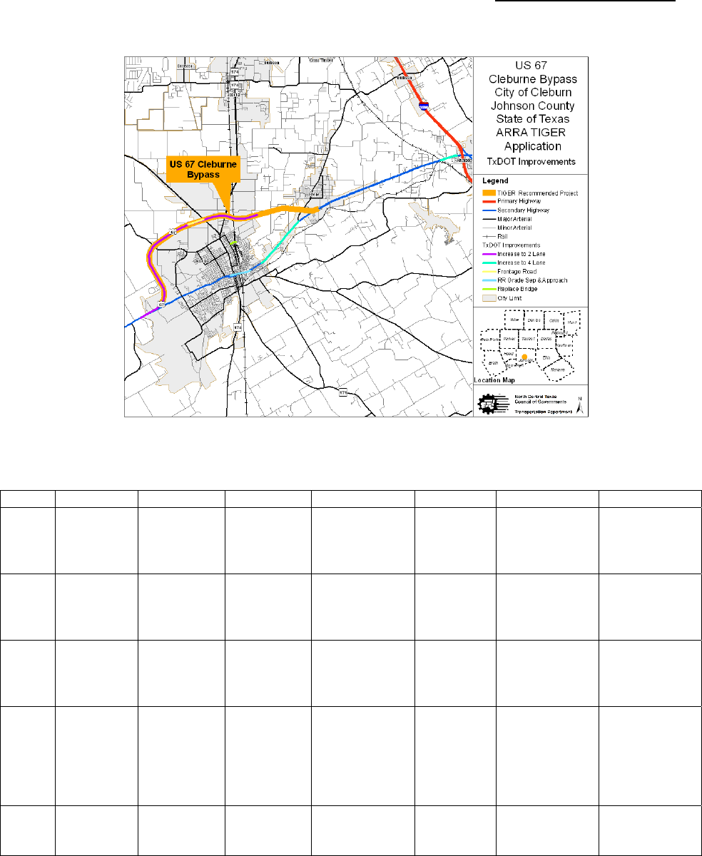
Project Scope or Description: The existing facility is located on the north side of the City of
Cleburne and is currently a two-lane roadway with grade separations at major intersecting
roadways, see Exhibit 1. The proposed project is an ultimate four-lane facility, for which all right-
of-way has been acquired. To facilitate the anticipated economic development, a frontage road
section was completed between US 67 at County Road 1216 (Nolan River Road) to SH 171.
Initially, construction of the bypass provided improved local and regional mobility; however, the
quality of this access has deteriorated since the bypass was completed in 1998, due to traffic
growth and the increasing high percentage of trucks. The completed four-lane divided bypass
will improve accessibility to public facilities and private property in the northwest and northeast
quadrants of the city, with implicit benefits to those in downtown Cleburne, as this facility routes
through traffic away from the central business district. To meet long-range system planning
needs, the facility has been designed to allow an extension should construction of a highway for
the southeast quadrant become warranted.
Exhibit 1 – Project Location Map

US67CleburneBypass,Cleburne,JohnsonCounty,Texas
___________________________________________________ARRATIGERAPPLICATION
Page 3 of 25
Table 1 compares the ADT for the Northeast and Northwest quadrants of the bypass,
respectively east and west of SH 174, as estimated in the 1989 FEIS and based on 2008 traffic
count data. Currently, level of service varies along the bypass from “D” to “E.”
Table 1 – Comparison of Estimated 2011 Year Traffic with 2008 Traffic Count Data
Northeast Quadrant Northwest Quadrant
1989 FEIS
2011 Average Daily Traffic Projection (ADT)
13,100 11,100
2008 Traffic Count ADT 15,100 11,000
2008 % Trucks >20%
(1)
15% to 20%
Level of Service D, E D, E
Notes: (1) Typically, truck percentage of the ADT ranges between 8% to12%
Urban vs. Rural Need: This TIGER grant is sought to fund the final construction phase of the
US 67 Cleburne Bypass by the construction of two additional main lanes. The City of Cleburne
may be characterized as a rural community; it is the county seat of Johnson County. The
bypass’ original intent was to address the City of Cleburne’s increasing traffic congestion due to
the city’s steady growth and regional through traffic. The current bypass partially achieves this
intent of reducing city congestion by shifting auto and heavy truck traffic from the central
business district’s main thoroughfares onto the two-lane bypass. Limestone and aggregate
quarries located southwest of Cleburne, and more significantly, the recent advent of natural gas
well drilling throughout Johnson County exacerbate the bypass’ congested condition through the
addition of more haul trucks to the traffic mix using the US 67 bypass. The proposed project
completes the ultimate four-lane facility envisioned more than 30 years ago, which was initially
environmentally cleared 20 years ago, for which the needed right-of-way has been acquired,
design is at 95% complete and for which the first phase of construction (the two-lane bypass)
ended ten years ago.
Targeted Transportation Challenges: The existing two-lane roadway features grade
separations at various major intersecting roadways however, additional grade separations must
be constructed for the other half of the four-lane divided roadway. All necessary right-of-way is
in hand. Table 2 summarizes the US 67 Bypass’ phases, funding source, cost shares and
expenditure status.
The completed bypass will improve accessibility to a variety of public and privately owned
facilities; beginning near the western terminus of the existing bypass and moving in a clockwise
direction these public and private facilities include: the Harris Methodist Walls Regional Hospital,
a Wal-Mart Distribution Center, the Cleburne Municipal Airport, Cleburne High School, George
Marti Lake, Lake Pat Cleburne, and Hill College’s Johnson County Campus. Access to various
residential subdivisions in the northwest and northeast quadrants of the city will also be
improved by this project.
Table 2 – Phases, Funding Source, Cost Shares and Costs Status
Phase Funding Source
% Shares by
Source
Costs
Already
Incurred?
Engineering TxDOT – State Funds 100% Yes
Environmental
Review
TxDOT – State Funds
100% Yes
Right-of-Way TxDOT –
Local Funds
90% state
10% local
Yes
Utility Relocation TxDOT –
Local Funds
90% state
10% local
Yes
Construction TIGER Request No

US67CleburneBypass,Cleburne,JohnsonCounty,Texas
___________________________________________________ARRATIGERAPPLICATION
Page 4 of 25
Project Schedule: The project’s design plans for the two-lane capacity improvement are 95%
complete. All necessary right-of-way (ROW) has been acquired; as the two lanes will be
constructed within existing TxDOT ROW only the relocation of utility poles are needed.
If TIGER funds are awarded, this project would let in August 2010 and completion is estimated
to occur in December 2012. Table 3 and 3A summarize the completed and pending phases of
the US 67 Bypass. Please note the section represented in Table 3A has been submitted for
ARRA funding; while this section is not a part of this project, it is being reported so that the
bypass’ entire proposed funding profile is known.
Table 3 - US 67 Cleburne Bypass Project Phases
Phase
Estimated/
Actual Start Date
Estimated/Actual
Completion Date
Roadway Segments
– from US 67 west of Cleburne to SH 121 Southwest Parkway
– from SH 174 to Spur 102
Environmental
Clearance
Record of Decision (ROD)
Issued: August 7, 1989
Re-Evaluation Approval:
May 14, 2003
Continuous Activity
pending 2009 MTP update
Design
Design began
around 2001
95% complete. Minor
revisions required to
extract a portion of
existing plan set for SH
121/US 67 ARRA project.
Right-of-Way
ROW for the
four-lane
ultimate section
acquired.
10.603 acres of additional
ROW acquired due to
design changes to
accommodate SH 121/US
67 interchange.
Utility Relocation
Completed
during Phase 1
construction
95% complete, minor
adjustment of utility poles
pending.
Construction
Phase 1: 2- lane
bypass
Phase 2: 4-lane
divided bypass
July 1998
December 2012
100% complete
Contingent on receipt of
TIGER funds.

US67CleburneBypass,Cleburne,JohnsonCounty,Texas
___________________________________________________ARRATIGERAPPLICATION
Page 5 of 25
Table 3A - US 67 Cleburne Bypass Project Phases
Phase
Estimated/Actual
Start Date
Estimated/Actual
Completion Date
Roadway Segment – from SH 121 Southwest Parkway to
SH 174 – NOTE: This project is a candidate for $10 million in
ARRA funds and is included to account for all proposed
improvements for the Bypass.
Environmental
Clearance
Pending update of 2009
MTP to separate out
from US 67 Bypass
project. Anticipate
approval in October
2009.
Design 2001 100% complete
Right-of-Way
ROW for the
four-lane
ultimate section
acquired
100% complete
Utility Relocation
Completed
during Phase 1
construction
100% complete
Construction
Begin
construction
November 2009
March 2011
Legislative Approvals Needed: Legislative approvals are not required for this project.
Letters of Support: Letters from the Texas Department of Transportation and the City of
Cleburne, supporting for the US 67 Bypass project may be retrieved by utilizing the following
link:
http://www.nctcog.org/trans/tip/private/67Letters.pdf
State, Regional and Local Planning:
State Planning
: This project is an integral part of TxDOT’s highway system improvements
envisioned for the US 67 corridor, involving railroad grade separations, bridge replacements and
the widening of US 67 from two- to four-lanes. These improvements have spanned 15 years
(counted from the first construction contract only) and represent a transportation construction
investment totaling almost $71 million. Exhibit 2 depicts the spatial relationship of these
improvements to each other; while Table 4 summarizes each improvement’s location, scope,
completion date and cost.
US67CleburneBypass,Cleburne,JohnsonCounty,Texas
___________________________________________________ARRATIGERAPPLICATION
Page 6 of 25
Exhibit 2 - US 67 Corridor Transportation Improvements
Table 4 - US 67 Corridor Transportation Improvements
CSJ Roadway From To Description Letting Completion Cost
0259-
05-
036
BU 67M
Boyd St.;
east side
of
Cleburne
E of FM
2280
Widen 2 to 4 2/91 3/93 $ 5,831,181
0259-
05-
037
US 67 Spur 102
West of
Chambers
Creek
Bridge
Construct 4
Lane Divided
Rural
8/00 1/04 $13,696,516
0259-
05-
038
US 67
0.154 Mi.
East of
SH 174
Kouns St.
in
Cleburne
Construct RR
Grade
Separation &
Approaches
4/93 7/95
$ 4,443,958
0259-
05-
041
US 67
SH 174 N.
of
Cleburne
Existing
US 67
East of
Cleburne
Construct 2
Lanes
(Ultimate 4
Lanes, w/
Grade
Separations)
12/94 3/97 $13,464,083
0259-
05-
062
US 67
Chambers
Creek
Bridge
UPRR
Widen 2 to 4
Lane Divided
11/01 12/03 $ 2,014,952

US67CleburneBypass,Cleburne,JohnsonCounty,Texas
___________________________________________________ARRATIGERAPPLICATION
Page 7 of 25
Table 4 - US 67 Corridor Transportation Improvements (cont.)
CSJ Roadway From To Description Letting Completion Cost
0422-
03-
039
US 67
US 67 W.
of
Cleburne
SH 174
North of
Cleburne
Construct 2
Lanes
(Ultimate 4
Lanes w/
Grade
Separations)
8/92 7/95 $12,160,498
0422-
03-
056
US 67
1.193 KM
West of
SH 171
SH 171
Construct
Frontage Rd.
Connection
6/97 8/98 $ 470,274
0260-
01-
034
US 67 SP 379 E. Ellis C/L
Construct 4
Lane Divided
8/99 1/03 $15,035,646
0260-
01-
035
US 67
W. End
Chambers
Creek
Bridge
West of IH
35W
Widen to 4
Lane Divided
8/00 1/04 $ 1,009,547
0260-
01-
048
US 67
Chambers
Creek
West of IH
35W
Widen 2 to 4
Lanes
Divided
11/01 12/03 $ 1,034,865
0902-
50-
073
Boone St.
Boone St.
Bridge
Over
BNSF RR
In
Cleburne
Replace
Bridge &
Approaches
7/04 1/06 $ 1,740,103
Related to the US 67 Bypass improvements is the construction of the proposed Southwest
Parkway/Chisholm Trail (SH 121) from Fort Worth to Cleburne. The US 67 bypass is the
southern terminus of Southwest Parkway. Construction of the Southwest Parkway is expected
to begin in November 2009. As stated in Table 3A, the portion of the US 67 Bypass between
Southwest Parkway (SH 121) and SH 174 is a candidate for $10 million in ARRA funding.
Regional Planning
: With respect to long-term regional system planning efforts, the US 67
Bypass is an integral part of the current Metropolitan Transportation Plan, Mobility 2030,
Amendment 2009. The North Central Texas Council of Governments is also testing the
feasibility of a Regional Outer Loop or loop segments in response to the urbanization which
continues outward from the urban core. Given the current constraints on toll financing and
comprehensive development agreements imposed by the Texas Legislature, coupled with
increasing costs of materials, labor and right-of-way certain loop segments are being considered
as multiplexed facilities; i.e. improvements which would lie within existing roadway corridors. In
this case, one of the corridors being considered in the southwest region of the Dallas-Fort Worth
Metroplex lies along a significant portion of the US 67 Bypass. There are several reasons to
consider multiplexing – it is an optimal use of existing right-of-way, it minimizes impacts to the
community and natural environments, it reduces sprawl and focuses future growth within an
existing corridor. Implementation of the outer loop is twenty years or more in the future; the goal
of the current study is to identify possible corridors so counties and cities may identify a corridor
on their regional thoroughfare plans and/or begin right-of-way acquisition.

US67CleburneBypass,Cleburne,JohnsonCounty,Texas
___________________________________________________ARRATIGERAPPLICATION
Page 8 of 25
Local Planning: Locals from the City of Cleburne and Johnson County have a long-standing
tradition of championing the Cleburne Bypass to ensure a well developed local and regional
transportation network. In November 1973, a delegation from Cleburne took the initiative and
requested that the Texas Transportation Commission authorize a Cleburne bypass. Project
milestones illustrating how and when locals participated and influenced the project’s local
planning process are fully detailed in the Livability section. In brief, some of these early major
milestones include:
• November 1973 – Delegation from Cleburne requested Texas Transportation
Commission to authorize the SH 174 Cleburne Bypass. (The project was originally
visualized as a north-south bypass for SH 174.)
• October 1974 – A public meeting was held to gather citizen input related to the
proposed SH 174 Bypass. The general area of the bypass was discussed. All
persons making statements expressed support for the bypass project.
• November 1974 – A delegation of local government and business leaders appeared
before the Commission in support of the SH 174 Bypass.
• June 1982 – A delegation of local government and business leaders appeared
before the Commission in support of the US 67 Bypass. The delegation requested
that the northeast quadrant in addition to the northwest quadrant be included to help
relieve congestion on US 67 as well as SH 174.
• June 1982 – A Commission Minute Order was passed supporting the US 67 Bypass,
placing the northwest quadrant in the four-year letting schedule, the northeast
quadrant in the five-year letting schedule, and the southwest quadrant in the twenty-
year plan.
Johnson County’s active support of the US 67 Bypass is evidenced through its current Johnson
County Thoroughfare Plan dated 2001. This plan is consistent with the regional transportation
planning process as developed by North Central Texas Council of Governments, the
Metropolitan Planning Organization for the Dallas-Fort Worth (DFW) Metropolitan Area.
The County’s Thoroughfare Plan’s primary goal is “…to allow the orderly and efficient expansion
and improvement of the thoroughfare system to serve existing and future transportation needs.”
Articulating this primary goal is a set of secondary goals, a subset of which provides for:
- “encouraging public participation in the development of a balanced transportation
system capable of moving both people and goods in a safe, expeditious, economical
and environmentally sensitive manner.”
- “promoting neighborhood integrity and safety by diminishing cut-through and truck
traffic.”
- “recognizing the impact of the regional thoroughfare system on the community, and
maintain improved coordination with the various elements of the system.“
Two of the six specific recommendations of the thoroughfare plan include the construction of
the SH 121/US 67 Bypass interchange (the ARRA candidate project previously alluded to) and
the improvements proposed for the US 67 Bypass.
TIP/STIP Status: This project is in the current Metropolitan Transportation Plan, Mobility 2030,
Amendment 2009, but it is not in the current Transportation Improvement Program. If TIGER
funds are awarded to this project, the North Central Texas Council of Governments certifies it
will be amended into the plan in advance of construction.

US67CleburneBypass,Cleburne,JohnsonCounty,Texas
___________________________________________________ARRATIGERAPPLICATION
Page 9 of 25
Metropolitan Transportation Plan: The proposed US 67 Cleburne bypass project is
consistent with the recommendations found in Mobility 2030: The Metropolitan Transportation
Plan for the Dallas-Fort Worth Area, 2009 Amendment. The Metropolitan Transportation Plan
includes this project as a four-lane freeway with grade-separated crossings and in an
interchange with the Chisholm Trail Parkway (SH 121).
Because Johnson County is classified as non-attainment for the pollutant ozone, transportation
conformity applies. This project is included in a conforming Metropolitan Transportation Plan
and will be amended into the State Transportation Improvement Plan.
Statewide Transportation Plan: While the US 67 Bypass is in Johnson County, it was not
explicitly identified in the 2006 TMMP. However, the improvements proposed by this project
support the major goals of the 2006 TMMP; namely to relieve congestion, improve safety,
improve air quality, improve quality of life, improve opportunities of enhanced economic
development, increase value of transportation assets and streamline project delivery.
Technical Feasibility: Technical feasibility is typically a function of a project’s engineering
components/phases relating to environmental clearance, design, final environmental permitting
based on final design, right-of-way acquisition, utility adjustments, relocation of residential and
commercial land-owners and/or constructability issues. Parcel acquisition for the Cleburne
Bypass is complete, while design work and utility adjustments are 95% complete. Minimal
constructability issues are anticipated for the following reasons: 1) the lion-share of construction
will occur within existing right-of way, 2) grade separations were constructed 10 years ago
(Phase 1 construction) to accommodate one-half of the ultimate four-lane roadway, so
connectivity at these grade separations may be maintained during construction, 3) disruptions to
local businesses are anticipated to be minimal to nil, as locally requested access roads were
likewise constructed 10 years ago to facilitate and maintain local access during final
construction.
Financial Feasibility: Table 2 on page three, depicts the project’s funding breakdown. Except
for the TIGER funding request for construction funding, the capital costs for design, right-of-way
acquisition and utility adjustments have essentially been incurred by various federal, state,
county and municipal agencies. As summarized in Table 4 and illustrated in Exhibit 2,
transportation system improvements in this corridor began in 1991 and expenditures currently
amount to approximately $71 million. TIGER funding for the US 67 Bypass (in conjunction with,
and assuming receipt of the $10 million ARRA funds for the segment between SH 121 and
SH 174) is the sole source of construction funding for this project. The full award of these funds
will allow finalization of highway system improvements envisioned more than 30 years ago.
Current Financial Constraints:
As in other parts of the country, the Dallas-Fort Worth region is
facing serious funding shortfalls relative to implementing needed transportation infrastructure
improvements. For the DFW region, and through the year 2030, $71 billion in funded
transportation need has been identified; $59 billion in unfunded need has also been identified. In
recognition that local governments must be more self-reliant and find innovative financial means
to build and maintain their transportation systems, during the past three Texas legislative
sessions, NCTCOG, the Metropolitan Planning Organization, in concert with other Texas
governmental entities, have attempted to have the Texas legislature pass various tax increases
to fund transportation improvements. This past legislative session, the region unsuccessfully
championed the Texas Local Option Transportation Act (TLOTA), which would have allowed
counties and municipal governments to assess fees for vehicle registration, driver’s license,

US67CleburneBypass,Cleburne,JohnsonCounty,Texas
___________________________________________________ARRATIGERAPPLICATION
Page 10 of 25
parking, etc. as a revenue stream to fund needed transportation improvements. While attempts
at finding alternative revenue streams will not cease, funding for this project is needed now.
The Dallas-Fort Worth region is unique in that we have a Regional Toll Revenue (RTR) program
through which excess toll revenues are proportioned to participating counties to apply to
multimodal improvements. Johnson County is a recipient to receive RTR funds however, current
funding in its account is insufficient to solely fund major improvements.
Grant Managerial Experience:
NCTCOG currently manages federal as well as state
administered grants, which are in various stages of development, implementation and close-out.
In fiscal year 2008, NCTCOG facilitated expenditures of $4.8 million from various multi-year
grants including awards from the Department of Energy, Environmental Protection Agency,
Federal Transit Administration, Federal Aviation Administration, US Department of Housing and
Urban Development, Department of Labor, and the Department of Defense. Also in fiscal year
2008, NCTCOG facilitated expenditures of $113.7 million from various state administered grants
including awards from the Texas Commission on Environmental Quality, Texas Department of
Health, Texas State Energy Conservation Office, and TxDOT. The Transportation Department
employs 18 fiscal and grant professionals who provide financial, legal and compliance support
for projects funded from various grants
No adverse audit findings from standards used by States, local governments and non-profit
organizations expending Federal awards (Circular A-133) have been found at this time.
NCTCOG has not been required to comply with special “high risk” terms and conditions under
agency regulations in the implementation of consistency and uniformity in the management of
grants and cooperative agreements with State, local, and federally recognized Indian tribal
governments (OMB Circular A-102).
Certification of compliance with Subchapter IV of Chapter 31 of Title 40 (federal wage rate
requirements) may be accessed through the following link:
http://www.nctcog.org/trans/tip/private/67FedWage.pdf
1511 Certification
– Please utilize this link to verify 1511 Compliance:
ftp://ftp.dot.state.tx.us/pub/txdot‐info/stimulus/1511_certification_letter.pdf
Environmental Outcomes
NEPA Approval Dates: Record of Decision: August 7, 1989
Re-Evaluation Approval: May 12, 2003
Relative to the project’s impacting natural, social or economic environment, the following
Conclusion Section is excerpted from the May 2003 Environmental Re-Evaluation: “The
environmental documentation for this project has been reviewed, and it has been determined
that there have been no significant changes to the assessed areas. Significant environmental
effects are not expected to occur as a result of changes to the location of the US 67/CR 1216
(Nolan River Road) interchange. The project effects as described in the US 67 EIS remain valid.
No additional public involvement is required, and no new comprehensive analysis of the entire
project is warranted.”

US67CleburneBypass,Cleburne,JohnsonCounty,Texas
___________________________________________________ARRATIGERAPPLICATION
Page 11 of 25
Quantification of Water Quality Impacts – as excerpted from the 2003 FEIS Re-Evaluation for
the US 67 Bypass, “… the project is located more than five miles upstream from the segment
(the Nolan River, which is designated as segment 1227 in the 2002 Clean Water Act Section
303(d) list, as impaired for bacteria and sulfate levels). Therefore, coordination with TCEQ is not
required for total daily maximum loads. The water quality of waters in the State shall be
maintained in accordance with all applicable provisions of the Texas Surface Water Quality
Standards including the General, Narrative and Numerical Criteria.”
There are a variety of environmental permits that will be required, however, these permits are
standard practice and no problems are foreseen in securing them. As required by the approved
FEIS Re-Evaluation, the project will require a USACE Nationwide Permit 14 (linear
transportation project) and typical construction permits relating to storm-water pollution controls
that will be obtained. The design change which mandated the FEIS Re-Evaluation required an
additional 10.6 acres; this property has also been acquired and meeting(s) with affected
property owners (MAPO) took place in 2003.
Web link to environmental documents -
Final Environmental Impact Statement:
http://www.nctcog.org/trans/tip/private/67FinalEIS.pdf
FEIS Re-Evaluation Approval:http://www.nctcog.org/trans/tip/private/67FEISApprv.pdf
Description of Needed Federal Actions: For this project, permanent losses to Waters of the
U.S. will be below 0.10 acre per location. A US Army Corps of Engineers Nationwide Permit #14
(Linear Transportation Projects) will be assumed, as will a Section 401 from TCEQ. Because
there are no navigable waters associated with this project, neither a US Coast Guard Section 9
Permit nor a USACE Section 10 Permit will be required. As these permits and certifications are
typically required for many highway projects, and as TxDOT is experienced in securing them, no
difficulties are foreseen in obtaining them.
Long Term Outcomes
State of Good Repair: The Texas Department of Transportation (TxDOT) has a fully
implemented asset management plan for existing roads and bridges on the state system, which
will include this project’s capacity improvements upon completion. As part of its asset
management effort, TxDOT conducts an annual assessment and inspection program of its
major assets, summarizes the findings and makes recommendations for maintenance efforts.
TxDOT uses an inventory and condition assessment process to report condition ratings and
replacement costs associated with its major assets. This assessment provides a basis for the
prediction of costs needed to maintain assets and manage funding needs. Typical activities will
include striping, pavement maintenance, pavement rehabilitation, landscaping rehabilitation,
coated surface remediation and bridge related maintenance activities such as bearing
replacement, decking repairs and skid resistance texturing, and seal integrity. TxDOT’s assets
are maintained with a view of the “total” cost or “life” cost of the assets. Maintenance and
rehabilitation is planned to prevent significant deterioration. This approach saves money over
the life of the assets and provides the best experience for the roadway user. Industry practices
are followed to assess the condition of the assets in order to plan and manage the maintenance
activities.

US67CleburneBypass,Cleburne,JohnsonCounty,Texas
___________________________________________________ARRATIGERAPPLICATION
Page 12 of 25
The existing two-lane section of the US 67 bypass pavement structure is continuously
reinforced concrete pavement (CRCP). Construction began in October 1992 and lasted until
July 1998. Current truck traffic on US 67 is significantly higher than most rural highways (typical
percent trucks vary between 8% to 12%) with more than 20% trucks east of SH 174, and
between 15% to 20% west of SH 174. As only discontinuous frontage roads are provided, they
provide no “relief” to the axial loadings experienced by the existing main lanes. The proposed
widening to four-lanes will help diffuse this loading and lessen any impairment to economic
stability and growth attributable to the highway infrastructure by extending the CRCP pavement
life another 30 years.
Status of US 67 pavement condition, per TxDOT Pavement Management Information System:
• FY 2007 – all pavement was rated in “very good” condition
• FY 2008 – a single section east of SH 174 slipped to “good”
• FY 2009 – ratings have declined significantly, with sections now in every category
(very poor, poor, fair, good and very good) Each of these categories is associated
with a range of pavement scores.
• NOTE: between FY 2008 and FY 2009 TxDOT maintenance inspectors noted that
bypass’ pavement condition as ‘high levels of distress.’ The bypass’ pavement,
continuously reinforced concrete pavement (CRCP), is normally expected to perform
longer before experiencing this level of distress. However, the high percentage of
truck traffic is reducing the useful life of the pavement. The increase in truck traffic is
attributed to significant increases in natural gas drilling and related activities
throughout Johnson County. Most trucks traveling east and west use US 67 bypass
to avoid driving through Cleburne’s central business district. Other generators of
truck traffic; aggregate quarries and the Wal-Mart Distribution Center are also
located in the area.
Economic Competitiveness: The US 67 Bypass’ economic competitiveness will be presented
first by describing the cost benefit of the project and then examining these benefits as impacting
economically distressed areas based upon a two and five mile radius around the US 67 Bypass
corridor. The US 67 Bypass Economic Impact Analysis is available through this link:
http://www.nctcog.org/trans/tip/private/67EcoImpact.pdf
Long-term Benefits:
Based off of a cost benefit model developed by NCTCOG staff, the US 67
Bypass project should have a net positive effect on the economy of $22.4 million annually and
create 244 permanent jobs when completed. This project will have a long-term return on
investment of 557% and generate 139% in taxes as the project cost (assuming a 25% capture
rate).
The 244 permanent jobs created by this project will be spread across a wide spectrum of
businesses. Cleburne is part of the booming Barnett Shale natural gas field and has seen
increased traffic as a result. This has added to already high truck traffic from rock quarries in the
area. The road is also likely to be a primary route for materials during the proposed expansion
of Comanche Peak. Improved roads will allow these businesses to operate more efficiently and
for other business to move to an area they would have otherwise avoided. Increased
accessibility and reduced congestion will improve all of these businesses and encourage
increased investment in the area.

US67CleburneBypass,Cleburne,JohnsonCounty,Texas
___________________________________________________ARRATIGERAPPLICATION
Page 13 of 25
Construction Benefits: During construction 204 jobs will be generated over the two year
construction period. The 204 jobs created during construction will be primarily construction
workers, their venders and retail and service jobs supported by their spending.
Cost Benefit as Applied at the Geographic Level:
The areas within two-mile radius of the US 67
Bypass project are economically distressed (by definition in 42 USC3161). According to the
2000 Census, the median income in the two-mile radius of the project area was $36,848,
compared to the national average at $41,994. The poverty rate within a five-mile radius of the
project area was 13.4% compared to the regional average at 8.1 %. Maps depicting the median
income, poverty rate,, and environmental justice populations (i.e., minority and low income) in
the two- and five-mile areas of interests, are provided in Exhibits 3 through 5. According to the
NCTCOG’s 2030 Forecast, the number of jobs in the five-mile radius of the project area in 2000
was 26,426. The number of jobs is projected to increase to 31,958
in 2015 and 63,696 by 2030.
The long-term efficiency, reliability and cost-competitiveness of this project in the movement of
workers and goods, results in direct benefits & savings to the unemployed and environmental
justice (EJ) populations depicted in the exhibits referenced above, as follows:
Construction
Cost Total
TIGER
Request
Annual Net
Benefit of
Hours Saved
(Congestion
Delay Savings)
Annual Net
Benefit of
Pollution
Reduction
Annual Net
Benefit of
Fuel Saved
Annual Net
Benefit of
Lives Saved.
$50,000,000 $50,000,000 $23,592,757 $259,945 $1,108,275 $1,599,638

US67CleburneBypass,Cleburne,JohnsonCounty,Texas
___________________________________________________ARRATIGERAPPLICATION
Page 14 of 25
Exhibit 3 - Median Income
Exhibit 4 - Poverty Rate

US67CleburneBypass,Cleburne,JohnsonCounty,Texas
___________________________________________________ARRATIGERAPPLICATION
Page 15 of 25
Exhibit 5 - Environmental Justice Areas
The industry profiles of City of Cleburne and Johnson County mirror each other and imply a
diverse economic base; it is anticipated that this diverse economic base will enable a
moderately fast economic recovery. See Table 6. Within the two- and five-miles of the study
corridor are City of Cleburne employers with 100 or more employees; Exhibit 6 depicts these
employers - please note that a large clustering of these employers are located within two miles
of the bypass. As the economy stabilizes, it is anticipated that improvement of the bypass will
ensure and foster enhanced access to these employment centers, as well as throughout
Johnson County. Currently, the unemployment rates have doubled in Cleburne and Johnson
County. The Texas Workforce Commission’s latest unemployment rates for Cleburne for July of
2007, 2008 and 2009 yields respective rates of 4.4%, 4.7% and 9.5%. For the same month and
years, the Texas Workforce Commission rates for Johnson County are respectively, 4.6%, 4.9%
and 9.2%.
Table 6 - Industry Profile Cleburne / Johnson County
Industry Profile
City of Cleburne - Source:
Census 2000
(Percent)
Johnson County – Source 2000
Census (Percent)
Agriculture, forestry, fishing, hunting
and mining
0.8 1.4
Construction 10.0 10.5
Manufacturing 19.7 19.2
Wholesale trade 3.7 4.1
Retail trade 14.6 12.9
Transportation/warehousing, and
utilities
6.5 6.2

US67CleburneBypass,Cleburne,JohnsonCounty,Texas
___________________________________________________ARRATIGERAPPLICATION
Page 16 of 25
Table 6 - Industry Profile Cleburne/Johnson County (cont.)
Industry Profile
City of Cleburne -
Source: Census 2000
(Percent)
Johnson County – Source
2000 Census (Percent)
Information 1.2 2.1
Finance, insurance, real estate, leasing 4.3 5.2
Professional, scientific, management, and
waste management services
5.7 6.2
Education, health and social services 20.2 17.9
Entertainment, recreation, hotel, food
services
4.4 5.2
Other services (except public
administration)
5.0 5.1
Public administration 3.9 4.0
Relative to the introduction of new industries since the last decennial census, the natural-gas
boom has had a significant effect on Cleburne. More than 200 wells have been drilled within
Cleburne’s 30-square mile border in recent years, and hundreds more have been drilled in
surrounding Johnson County. As previously discussed, the movement of this industry’s rigs and
equipment through the area are adversely impacting the US 67 Bypass pavement.
Based on the NCTCOG’s major employer data, there are 16 major employers (over 100
employees) in the two-mile radius of the project area, as shown in Exhibit 6. The major
employers in two-mile radius employ about 3,010 employees. The five-mile radius of the project
area contains 23 major employers that employ a total of 4,414 workers. According to
NCTCOG’s 2030 Forecast, the number of jobs in the five-mile radius of the project area in 2000
was 26,426. The number of jobs is projected to increase to 31,958
in 2015 and 63,696 by 2030
in the five mile-radius of the project area. These employers and businesses will significantly
benefit by the US 67 Bypass project due to reduced traffic congestion, improved access of the
customer base and better flow of traffic for goods movement.
Exhibit 6 – Major Employers (over 100 employees)

US67CleburneBypass,Cleburne,JohnsonCounty,Texas
___________________________________________________ARRATIGERAPPLICATION
Page 17 of 25
Livability: Cleburne is the county seat of Johnson County; it is the County’s second most
populous city with growth being primarily attributed to suburbanization. This section’s discussion
will cover demographic data, transportation infrastructure, and public involvement history.
Demographic data for the city is presented in Table 7.
Table 7 - City of Cleburne Demographic Data
General Characteristics Source: Census 2000 Demographic
Profile
Number Percent U.S.
Population
26,005
Median Age (years) 33.2 (x) 35.3
65 years and older 13.8 12.4
Ethnicity
(1)
White 86.3 75.1
African American 4.4 12.3
Asian 0.4 3.6
Hispanic or Latino (of any race) 19.9 12.5
Other (Pacific Islander, Native American, etc.)
Social Characteristics
Disability Status (population 5 years and older) 25.6 19.3
Speak a language other than English at home (population 5
years and older
17.4 17.9
Economic Characteristics
In Labor Force 61.7 63.9
Mean Travel time to work in minutes (workers 16 years and
older)
25.2 25.5
Median Household Income in 1999 (dollars) 35,481 41,994
Families below poverty level 10.0 9.2
Individuals below poverty level 13.5 12.4
(1)
Ethnicity percentages will not total to 100, as “Hispanic” may be counted under other groups.
For consistency in methodology, the same two- and five-mile envelopes, or areas of interests,
that were used to establish economic competitiveness will be used in examining and
characterizing the impact of this facility on Cleburne’s population.
According to the NCTCOG’s 2030 Forecast estimates, the two-mile radius of the project area
includes 33,750 population, 12,530 households, and 18,641 jobs in 2010. The NCTCOG’s
projections show that the five-mile radius of the project area includes 56,029 population, 20,625
households, and 30,419 jobs in 2010. The population, employment, and household estimates
for the 2- mile and 5-mile radius are presented, respectively, in Tables 8 and 9. The households
and businesses captured within these two and five mile areas will be direct beneficiaries of the
bypass’ anticipated improved level of service.
Table 8 - Household Population and Employment Estimates (2-Mile Radius)
2000 2010 2015 2030
Population 26,447 33,750 42,850 73,320
Households 9,624 12,530 16,176 28,428
Employment 16,154 18,641 19,581 42,031
Basic 4,634 5,271 5,488 12,300
Retail 3,817 4,441 4,702 9,574
Service 7,703 8,929 9,392 20,160

US67CleburneBypass,Cleburne,JohnsonCounty,Texas
___________________________________________________ARRATIGERAPPLICATION
Page 18 of 25
Table 9 - Household Population and Employment Estimates (5-Mile Radius)
2000 2010 2015 2030
Population 43,995 56,029 70,409 124,706
Households 15,933 20,625 26,210 47,514
Employment 26,426 30,419 31,958 63,696
Basic 7,226 8,298 8,689 18,266
Retail 6,637 7,663 8,082 15,566
Service 12,563 14,457 15,186 29,865
Source: 2030 Demographic Forecast – North Central Texas Council of Governments
Transportation Infrastructure:
Regional considerations - For the City of Cleburne and Johnson
County, of equal regional importance to the US 67 Bypass is the implementation of the long-
anticipated Southwest Parkway (SH 121). This facility will provide Johnson County residents
with a long needed conduit into the City of Fort Worth to Cleburne. Located in the lower left-
hand corner of Exhibit 7, the location of SH 121 (shown in green, the North-South radial facility
originating in Fort Worth) and the US 67 Bypass (shown in red) illustrates how these facilities
interact with other planned Mobility Plan improvements.
The possibility of multi-modal connections benefiting Johnson County communities is best
illustrated through Exhibit 8 – Rail Recommendations. Comparing the location of a proposed
regional commuter rail line, from Fort Worth to Cleburne, to the Roadway Recommendation in
Exhibit 7 demonstrates that a multi-modal regional transportation solution is being pursued in
this area of the metroplex.
Local Considerations
- The impact of this facility will be profound for Cleburne as well as
Johnson County. Even though the US 67 Bypass lies on the northern perimeter of Cleburne, it
connects major employment centers and residential locations along the city’s east-west axis.
Given the employment and residential centers connected by the Bypass, it is not surprising that
use of the Bypass is not confined to automobiles and truckers. The County’s transit agency,
CleTran, also utilizes the US 67 Bypass to provide city and county demand response service
and commuter bus service into Fort Worth. The CleTran Transit Manager characterizes the US
67 Bypass as one of CleTrans’ primary routes, for which the majority of riders are the elderly
and low-income. The Transit Manager also stated that the poor condition of the pavement,
along the 67 Bypass and elsewhere in Johnson County is of concern, as it impacts their fleet
maintenance costs. The Transit Manager was unable to provide data regarding ridership or
maintenance costs.
In addition, the project is in close proximity to the Cleburne Municipal Airport and Burlington
Northern Santa Fe (BNSF) and Union Pacific (UP) rail lines, which provides the potential for
enhanced inter-modal connections. Cleburne is fortunate to boast that it has a municipal airport,
three rail service providers, 25 motor freight carriers, three parcel-service providers, and two
piggyback service and switching providers. For a rural community, Cleburne offers its residents
and businesses an array of shipping options. Its airport and rail freight connections, relative to
the US 67 Bypass, are shown in Exhibit 9.

US67CleburneBypass,Cleburne,JohnsonCounty,Texas
___________________________________________________ARRATIGERAPPLICATION
Page 19 of 25
Exhibit 7 - Mobility Plan 2030 - 2009 Amendment – Roadway Recommend
ations
Exhibit 8 - Mobility Plan 2030 - 2009 Amendment – Rail Recommendations

US67CleburneBypass,Cleburne,JohnsonCounty,Texas
___________________________________________________ARRATIGERAPPLICATION
Page 20 of 25
Exhibit 9 - Airports and Rail
Public Involvement:
Please refer to the maps on median income, poverty rate, and
environmental justice maps, respectively Exhibits 3, 4, and 5. As these exhibits illustrate, within
the bypass’ two- and five-mile envelopes, there are environmental justice populations. There
has been a long standing effort to involve not only these populations, but the community at large
in the planning process.
An overview of various types of public involvement activities for the US 67 Bypass follow:
• November 1973 – Delegation from Cleburne requested Texas Transportation
Commission to authorize the SH 174 Cleburne Bypass. (The project was originally
visualized as a north-south bypass for SH 174.)
• October 1974 – A public meeting was held to gather citizen input related to the proposed
SH 174 Bypass. The general area of the bypass was discussed. All persons making
statements expressed support for the bypass project.
• November 1974 – A delegation of local government and business leaders appeared
before the Commission in support of the SH 174 Bypass.
• June 1975 – The District Design Engineer conducted preliminary discussions with city
and county representatives to receive input on the bypass route possibilities.
• July 1975 – Project Concept Conference held with county and city officials on the SH
174 Bypass. The project, reasonable alternatives and public involvement plans were
described. A discussion of potential impacts revealed that businesses did not depend on
the highway for economic survival, and that existing congestion was a detriment to
downtown businesses. It was pointed out that a large percentage of Cleburne residents
work in the Dallas-Fort Worth Metropolitan Area; the project would provide safer and
easier access to their work. Since the bypass would run through a rural area, wildlife

US67CleburneBypass,Cleburne,JohnsonCounty,Texas
___________________________________________________ARRATIGERAPPLICATION
Page 21 of 25
impacts were expected, and community cohesion impacts were considered
unnecessary.
• June 1982 – A delegation of local government and business leaders appeared before
the Commission in support of the US 67 bypass. The delegation requested that the
northeast quadrant in addition to the northwest quadrant be included to help relieve
congestion on US 67 as well as SH 174.
• September 13, 1984 and November 20, 1984 – Project Concept Conferences.
• November 1984 – US 67 Bypass placed in TxDOT’s (formerly the State Department of
Highways and Public Transportation –SDHPT) Ten-Year Project Development Plan.
• June 1982 – A Commission Minute Order was passed supporting the US 67 Bypass,
placing the northwest quadrant in the four-year construction schedule, the northeast
quadrant in the five-year construction schedule, and the southwest quadrant in the
twenty-year plan.
• February 1985 – public meeting
• July 1986 – A draft environmental assessment was submitted to the Environmental
Affairs Division (ENV) of TxDOT.
• December 1988 – Draft Final EIS submitted to the Federal Highway Administration
(FHWA).
• August 1989 – Record of Decision issued by FHWA.
• 2003 Meeting(s) with Affected Property Owners, affected by the design change and the
acquisition of an additional 10.6 acres.
• May 2003 Re-Evaluation approved
Sustainability: An anticipated improvement in energy efficiency, a reduction in oil dependency
and lower greenhouse gas emissions have been quantified for this project and are presented in
Table 10 and Exhibit 10. The performance measures used to quantify these improvements were
vehicle of hours travel (VHT), average loaded speed, congestion delay and traffic delay. Fuel
consumption and carbon dioxide (CO
2
) emissions were estimated from the reduction in VHT for
the build and no build scenarios, based on the following assumptions:
• Fuel Consumption: 0.685 gallons/hour factor was utilized to calculate the Fuel
Consumption from Vehicle Hours of Travel.
1
• CO
2
Emission: 8788grams/gallon of gasoline emission factor was used to calculate the
CO
2
Emissions from Fuel Consuption.
2
• Project Life: 40 years is used as project life for all highway projects.
• Global CO
2
Emission Benefits: $33/Metric Tons of CO
2
emission was used to calculate
the Global CO
2
Emission Benefits.
3
Table 10 - Net Reduction and Percent Change between Build and No Build case in 2030
Parameter Build - No Build Percentage Change
`Vehicle Hours of Travel
(hours) -3,081.25 -0.049%
Speed (mph) -0.01 -0.026%
Congested Delay (hours) 263.58 0.025%
Traffic delay (hours) -407.08 -0.068%
CO
2
Emission (tons/day) -20.45 -0.049%
Fuel Consumed
(gallons/day) -2110.65 -0.049%

US67CleburneBypass,Cleburne,JohnsonCounty,Texas
___________________________________________________ARRATIGERAPPLICATION
Page 22 of 25
Exhibit 10 - Percent Change between Build and No Build case in 2030
It is anticipated that these reductions in travel time and pollutant levels will result in the
reductions of other criteria pollutants, such as carbon monoxides (CO), volatile organic
compounds, nitrogen oxides (NO
x
), and particulate matters (PM).
Safety: For the US 67 Bypass, there were 221 total crashes from 2003 – 2008 which includes
four fatalities. This roadway segment is not designated as a Hazardous Materials route and data
gathered between 2003 and 2008 indicates that no hazardous material spills occurred. An
analysis from the Federal Highway Administration summary report ”Safety Effects of the
Conversion of Rural Two-Lane Roadways to Four Lane Roadways,” indicates that conversion to
a four-lane divided roadway appears to result in a crash reduction of 40%. As calculated below,
the safety data indicates that construction of the US 67 Cleburne Bypass project will result in 15
fewer crashes per year and 590 fewer crashes over the 40 year life of the project.
Estimated 40% reduction
221 total crashes from 2003 – 2008
36.83 average per year
36.83 x 40% = 14.73
14.73 less crashes per year * 40 years (project life) = 589.2 less crashes fro a project life
of 40 years.
Designated Evacuation Route
: Bypass US 67 is one of the designated evacuation routes for the
Comanche Peak Nuclear Power Plant, which is located in Somervell County, southwest of
Cleburne.
Evaluation of Expected Benefits: See summation on page 24 and Cost/Benefit Analysis
on page 25.
Job Creation and Economic Stimulus: How the US 67 bypass project accomplishes job
creation and stimulates the economic is qualitatively and quantitatively described in the
economic competitiveness section. A summation of these benefits is provided on page 24.

US67CleburneBypass,Cleburne,JohnsonCounty,Texas
___________________________________________________ARRATIGERAPPLICATION
Page 23 of 25
Secondary Criteria:
1. Innovation: No innovative features or elements are a part of this project.
2. Partnership, Jurisdictional and Stakeholder Collaboration: This project exemplifies
a broad range of collaborative working relationships and/or partnerships between federal
agencies (USACE, USDOI, EPA, USFWS), state agencies (Texas Department of
Transportation, Texas Air Control Board, Texas Parks and Wildlife Department, Texas
Department of Agriculture, Texas Water Commission, Texas General Land Office, Texas
Historical Commission, Texas Railroad Commission), regional entities (the North Central
Texas Council of Governments, Johnson County), municipal entities/affiliates (City of
Cleburne, Cleburne Municipal Airport, Cleburne Independent School District), and
local/regional employers (Harris Methodist Walls Regional Hospital, Wal-Mart
Superstore, Wal-Mart Distribution Center). These all participated during and after the
bypass’ environmental clearance. FEIS route determination for minimizing future
constraints to the northern expansion of the municipal airport, access to the regional
hospital, or adverse impacts to the West Buffalo Creek flood detention reservoir,
accommodating the possible construction of a southeast bypass, were examples of
community needs taken into account in the location and design of the US 67 bypass.
Performance Monitoring:
Provide a plan for evaluating success of project that measures both short and long-term
performance of the primary and secondary criteria.
While NCTCOG is charged with preparing the TIGER application for the Texas Department of
Transportation (TxDOT), it is not appropriate for NCTCOG to bind TxDOT to any performance
monitoring plan outlined in this application; performance standards may change and/or more
innovative measures may come on line by the time this project’s construction begins. Therefore,
what is offered is a menu of performance measures which may be adopted by the Fort Worth
District of TxDOT.
Performance Measure Options
Short Term Performance Measures Long-Term Performance
Measures
State of Good
Repair
Construction Contracts – performance based
construction contracts with incentives and
penalties for timely completion of work,
warranties and other performance-based
specifications.
Reduction in number and square
footage of deficient bridge decks
Reduction in lane miles rated as
poor or fair
Pavement evaluation scores
Economic
Competitiveness
Measure enhanced economic opportunity by
monitoring rate at which developable land
with new or improved access is developed.
Measure enhanced economic
opportunity by monitoring rate at
which developable land with new or
improved access is developed.
Livability
Monitor air quality for number and frequency
of pollutant thresholds exceeded.
Monitor air quality for number and
frequency of pollutant thresholds
exceeded.
Sustainability
Monitor congestion levels, length of peak
periods
Monitor annual hours of delay.
Safety
Monitor crash, incident and fatality rates to
ascertain contributing factors to mitigate/
resolve.
Monitor crash, incident and fatality
rates to ascertain contributing
factors to mitigate / resolve.

US67CleburneBypass,Cleburne,JohnsonCounty,Texas
___________________________________________________ARRATIGERAPPLICATION
Page 24 of 25
US 67 Bypass Project - Summation of Expected Benefits
Long-term
Outcomes:
Quantification
of:
State of Good
Repair
Economic
Competitiveness
Livability Sustainability Safety
Fuel Savings
CleTrans,
county/city transit
provider, anticipated
fleet fuel
consumption
reduced.
-Daily Savings
= 2,111 gals
-Benefits over
the project life
=
21,950,750
gals
Time Savings
Anticipate increase
of CleTrans’ current
time savings (10
minutes) to the City
of Keene
-3,081 hours
per day
-Benefits over
project 40 yr
life -
32,045,000 hrs
-3,081 hours
per day
-Benefits over
project 40 yr
life -
32,045,000hrs
Greenhouse Gas
Emissions
-CO
2
Emissions
reduced –
20.45 tons /
day
-Benefits over
40 Yr project
Life - 212,635
tons
Quantification of
Public Health
Benefits
CO
2
Emissions
reduced –
20.45 tons /
day
An analysis of
the “before &
after”
intersection
serving Wall
Regional
Hospital was
not possible,
but emergency
access is
assumed to be
improved.
Other Benefits
- Extends
pavement life by
40 years.
- Better
accommodates
the 15% to 20%
of trucks utilizing
the Bypass.
- Net annual
economic impact of
$22.4 million / yr
- Long-term return
on investment of
557%
- Generate $139% in
taxes
-The creation of
244 permanent
and 204
construction
jobs in an
economically
distressed
area.
US 67 Bypass
is an
evacuation
route for the
Comanche
Peak Nuclear
Plant.
Social Benefits of
Reducing Crash
Costs, Pollutant
Emissions and
Other
Externalities
- 40% reduction
in crashes
- 15 less
crashes per
year
- 590 less
crashes during
project’s 40
year life.
- $1.6 million in
lives saved per
year.

US67CleburneBypass,Cleburne,JohnsonCounty,Texas
___________________________________________________ARRATIGERAPPLICATION
Page 25 of 25
US 67 Cleburne Bypass Project
Cost / Benefit Analysis
Benefits Unit Daily
Benefit
Annual
Benefit
1
Annualized
Project
Costs
2
Annualized
Cost /
Benefit
Calculation
2,3
Annualized
Cost/Benefit
Outcome
2,3
Vehicle Hours of
Travel Saved
Hours 480 124,800 2,565,000 20.55 $317.76/hr
Reduced Vehicle
Miles of Travel
3a
Miles 0 0 2,565,000 NA $8.27/mile
CO
2
Emissions
Reduced
Tons 20.45 5,317.00 2,565,000 482.41 $18,486/ton
Fuel Saved Gallons 2,111 548,860 2,565,000 4.67 $265/gal
Jobs Created by
Construction
Jobs 204 921 2,565,000 2,785.02 $14,090/job
Long-term Jobs
Created
Jobs 244 12,000 2,565,000 213.75 $1,081/job
1.TotalBenefitvs.AnnualBenefitprovidedforjobsbenefitsduetoavailabilityofdata.
2.Basedonadiscountrateof3%over30years,costsshownin2009dollars.
3.Calculatedbydividingtheannualizedprojectcostbytheannualbenefit
3a.ReducedVehicleMilesofTravelinsignificant,DailyBenefitzero.
Costs Costin2009Dollars Annualized
Project
Costs
4,5
Construction $50,000,000 $2,565,000
Total $50,000,000 $2,565,000
4.Basedonadiscountrateof3%over30years,costsshownin2009dollars.
5.Calculatedbymultiplyingconstructioncostsby.0513assupportedinPrinciplesof
EngineeringEconomicAnalysisbyJohnWhite,MarvinAgee&KennethCase,AppendixB,
TableB.6.
ThelinktotheCost/Benefitisavailableathttp://www.nctcog.org/trans/tip/private/67CBAnal.pdf.
